Remember Paul Ehrlich? Remember The Population Bomb? Global Cooling? To think that today’s memes of peak oil and the incipient death of Gaia are not, actually, all that new…
Oh so long ago… er, not so much.
via Richard Hernandez we are reminded-
George Will reviews environmentalism’s track record at predicting the future of the earth by the technique of reviewing the past. Using newspaper archives, Will takes us back to yesteryear where we are confronted by one of environmentalism’s many predictions of doom. Then he speeds the archival time machine forward to show what actually happened. The depressingly consistent result is that environmentalism has missed the mark by a country mile.
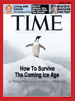
The modern disaster cycle began in 1972, when “when we were warned (by computer models developed at MIT) that we were doomed. We were supposed to be pretty much extinct by now, or at least miserable. We are neither. So, what went wrong?”
Well, they were just, ah, mistaken.
That didn’t stop the powers-that-be from capitalizing on the fear. Sadly, that didn’t work out so well…
As to the rest of the prediction, the furnaces of Pittsburgh are indeed cold and the assembly lines of Detroit are in fact still — but not for the reasons the environmentalists imagined. Pittsburgh, once known as “Steel City” has no steel mills left within the city limits. In Detroit the automotive assembly lines are kept fitfully moving only under the impetus of government subsidy. As for the remains of what used to be called Motor City, “the city of Detroit has a very strange, wild appearance, in some parts like a city of ruins many years older than it actually is, where nature reasserts itself in vegetation that spreads over the city’s crumbling structures.”
But the catastrophe which leveled these proud capitals was not due to anything the environmentalists predicted. On the contrary they were due to the failed attempts of the political process itself to manage that future. The combination of suicidal economic policies, a relentless pandering to unions and the special interest meddling of politicians — each undertaken for the ostensible purpose of making things better — succeeded in making things worse to a degree that is wondrous to behold. Surveying the ruins of industrial America Hanson notes elsewhere that “Hiroshima looks a lot better today than does Detroit”, raising the interesting possibility that recovering from a nuclear blast may be possible or at least a lot more likely than surviving terminally stupid political projects.
Of course the possibility that the current doomsayers are also not right, regardless of the quite recent track record, is discounted. So we get wind farms, E65 gas, and carbon credits. We get the relentless green drumbeat in the media, designed to make folks happy with their declining lifestyle because we’re doing it for Gaia, don’t you know. We get to choose paper or plastic in the grocery store, never noticing all the plastic packaging safety and health regulations require, and get to feel better about ourselves for picking paper.
The worst thing about political crusades is that they manufacture “facts”. That is to say they mass-produce lies. As a now-skeptical environmentalist Fritz Varenholt noted, movements to save the world tend to force the data into the narrative. After a while the public, force fed a diet of press releases, come to believe the narrative is the fact.
In other words, calling a spade a spade, we’re being lied to. I folks don’t wake up to this, well, then they can live with the chains they put on their own ankles.
Oh. Never mind.


